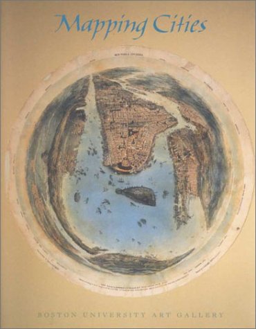
Mapping Cities charts both the development of urban planning in seven cities -- Jerusalem, Rome, Paris, Amsterdam, London, Boston, and New York -- and changes in mapmaking since the 15th century.Despite the ubiquity of city maps, urban cartography is a relatively recent discipline, quite distinct from the field of urban history. This book emphasizes the city map as a bearer of information and a graphic means of communication. It illustrates several little-known maps, including a never before published 1598 map of Jerusalem, an 1858 lithograph of New York in an orb, and a poster for the Tate Gallery advertising the London transport system. Also included are acknowledged landmarks such as Nolli's 1748 map of Rome, the Turgot map of Paris featuring detailed images of 18th-century Parisian life, and the McIntyre map of Boston.
- ISBN10 1881450139
- ISBN13 9781881450139
- Publish Date 1 March 2000
- Publish Status Out of Print
- Out of Print 11 July 2009
- Publish Country US
- Imprint University of Washington Press
- Format Paperback
- Pages 92
- Language English