Through Time
4 total works

Prestwich and Whitefield are closely linked townships that have been separated by the construction of the M60. With a combined population of around 55,000, they are considered to be prestigious suburbs of north Manchester. They are now part of Bury Metropolitan Borough Council. In this book, authors Paul Hindle and Harry Wilkinson offer a nostalgic visual chronicle of Prestwich and Whitefield through the decades.
Prestwich is the older of the townships and its parish church, St Mary's, dates back to Norman times, though the present church was begun in the fifteenth century. Much of Whitefield was part of the medieval Pilkington Park, and Clive of India attended Stand Grammar School there. Whitefield became a separate local government area in 1886, but it boasts one of the churches funded after the Napoleonic Wars. Between the two areas is the famous Besses o' th' Barn, named after a former local innkeeper. To the west is the Irwell Valley and Philips Park, while to the east is Heaton Park, once the seat of the Earls of Wilton. Prestwich & Whitefield Through Time will be of interest to local people and anyone with links to the area.
Prestwich is the older of the townships and its parish church, St Mary's, dates back to Norman times, though the present church was begun in the fifteenth century. Much of Whitefield was part of the medieval Pilkington Park, and Clive of India attended Stand Grammar School there. Whitefield became a separate local government area in 1886, but it boasts one of the churches funded after the Napoleonic Wars. Between the two areas is the famous Besses o' th' Barn, named after a former local innkeeper. To the west is the Irwell Valley and Philips Park, while to the east is Heaton Park, once the seat of the Earls of Wilton. Prestwich & Whitefield Through Time will be of interest to local people and anyone with links to the area.
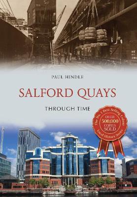
As recently as the 1870s the whole area which is now Salford Quays was largely empty, occupied by little more than a medieval hall and a racecourse. But in 1887 the construction of the Manchester Ship Canal began, and the largest docks were built on the Salford bank of the canal. These docks were called ‘Manchester Docks’ though they were often referred to as ‘Salford Docks’ both by locals and on maps.
The docks reached their peak traffic in the 1950s, but in 1982 the docks were closed and a plan to redevelop the area as Salford Quays was published. Within thirty years the area became home to a mix of developments including houses, apartments, offices, hotels, restaurants, shops, trams, the Lowry Theatre and art gallery, and MediaCityUK. Nearby are the former inner-city slum terraced areas of Ordsall and Weaste, now also much redeveloped for housing and industry.
The docks reached their peak traffic in the 1950s, but in 1982 the docks were closed and a plan to redevelop the area as Salford Quays was published. Within thirty years the area became home to a mix of developments including houses, apartments, offices, hotels, restaurants, shops, trams, the Lowry Theatre and art gallery, and MediaCityUK. Nearby are the former inner-city slum terraced areas of Ordsall and Weaste, now also much redeveloped for housing and industry.
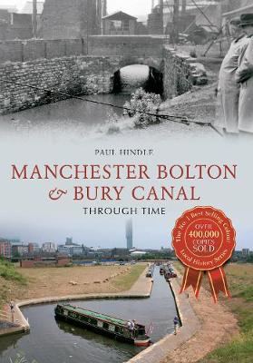
The canal received its Act of Parliament in 1791, and was opened from Bolton and Bury to Salford in 1797. The canal never reached Manchester. It was connected to the River Irwell in 1808 and to the rest of the canal system in 1838. The canal is just over 15 miles long, and has three arms radiating out from Nob End in Little Lever; all seventeen locks are on the Salford arm.
The canal principally carried coal, and there were over 6 miles of tramways linked to it. As the collieries closed, the canal followed between 1924 and 1966, though the massive breach near Nob End in 1936 cut off the Bury arm. A canal society was formed in 1987 to restore the canal, and the first length was reopened in Salford in 2008. The society built a unique Meccanostyle bridge at Little Lever in 2012.
The canal principally carried coal, and there were over 6 miles of tramways linked to it. As the collieries closed, the canal followed between 1924 and 1966, though the massive breach near Nob End in 1936 cut off the Bury arm. A canal society was formed in 1987 to restore the canal, and the first length was reopened in Salford in 2008. The society built a unique Meccanostyle bridge at Little Lever in 2012.
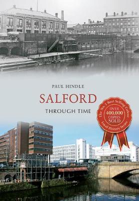
Salford is often seen as the smaller twin of Manchester, its neighbour across the River Irwell. In fact, Salford was a borough long before Manchester achieved that status, but even in the 1530s John Leland described it as 'a large suburb to Manchester'. However, during the Industrial Revolution, Manchester grew more rapidly than Salford, although together they were the first 'shock city' of the industrial age, described in graphic detail by writers such as de Tocqueville and Engels.
While Manchester city centre became the area's commercial heart, Salford was relegated to the periphery. It certainly had its grim areas, described by Ewan McColl: 'I met my love by the gas works wall, dreamed a dream by the old canal/I kissed my girl by the factory wall, dirty old town, dirty old town.' However, today's Salford is an up and- coming area, home to Media City. This book presents a photographic tour through central Salford, ending up on the 'old canal'.
While Manchester city centre became the area's commercial heart, Salford was relegated to the periphery. It certainly had its grim areas, described by Ewan McColl: 'I met my love by the gas works wall, dreamed a dream by the old canal/I kissed my girl by the factory wall, dirty old town, dirty old town.' However, today's Salford is an up and- coming area, home to Media City. This book presents a photographic tour through central Salford, ending up on the 'old canal'.