50 Maps of the World by Ben Handicott, Kalya Ryan

50 Maps of the World

by Ben Handicott and Kalya Ryan

50 Maps of the World is an essential addition to the bookshelf of any travel-lover, map-maestro or geography genius. Spanning the world from Spain to Singapore, Colombia to Canada, Turkey to Tanzania, discover all you need to know about some of the most awesome places on Earth.

Geography, history and culture spill from the pages in this luxuriously illustrated treasure-trove of travel knowledge. Each two-page spread is dedicated to a different country, providing both quick-fire facts and the chance to delve deeper into what makes every nation unique. Natural wonders, bustling metropolises, storied pasts and cultural icons are all presented in expert detail from experienced explorers Ben Handicott and Kalya Ryan, alongside Sol Linero's eye-popping artwork.


Meet our earliest ancestors in Ethiopia, marvel at Machu Picchu in Peru and visit the floating villages of Cambodia in this colorful guide to 50 fascinating countries.
Each spread includes dozens of spotlighted locations, a timeline of the nation's history and introductions to the people who have helped shape it.
With the expertise of Ben Handicott (Hello Atlas, Atlas of Adventures: Wonders of the World) and Kalya Ryan, alongside the stunning illustrations of Sol Linero (The 50 States, 50 Cities of the U.S.A.), experience the diversity of our world like never before.


50 Maps of the Worldreimagines what maps can be, providing not just a geographical fact-fest but a vivid insight into the history, culture and wildlife that shape our living world. It is the perfect gift for young globetrotters and armchair-travellers alike.

Reviewed by annieb123 on

4 of 5 stars

Share
Originally published on my blog: Nonstop Reader.

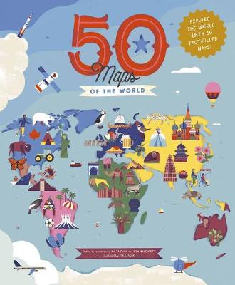
50 Maps of the World is an atlas of countries of the world presented with lots of trivia and timelines and highlights for each country represented. Due out 1st Sept 2020 from Quarto on their Wide Eyed Editions imprint, it's 112 pages and will be available in hardcover format.

This is a fun, information dense, graphically appealing (but very busy) atlas. Each of the maps shows an outline map of the country (or countries - Scandinavia is taken together, for example) in question, noteworthy cities, landmarks, cultural tidbits, and a timeline in a highlighted text box. There's another highlighted text box for each entry with key facts such as Capitals, languages, currency, two letter country codes, national birds and flowers, and populations. There are small cameo insets with notable figures from each country's history. The countries themselves are arranged geographically by continent, starting with Europe and ending with the Antipodes.

The authors have included a hunt & find activity search at the end of the book as well as a comprehensive index and an abbreviated glossary.

There's a lot to like here. I would recommend it for classroom/library use and it would also make a nice selection for home library or homeschool use. I'm not sure how long it'll remain current (as the author's state in their introduction, countries change continually), but it's a nice kid's atlas with appealing art. I was impressed that the authors managed to cover the 1994 Rwandan genocide in an age-appropriate manner.

Four stars.

Disclosure: I received an ARC at no cost from the author/publisher for review purposes.

Last modified on

Reading updates

  • Started reading
  • 29 July, 2020: Finished reading
  • 29 July, 2020: Reviewed