Book 47

The countryside around Edinburgh is ideal for walking comprising a superb mixture of rolling hills, expansive moorland and attractive rivers, bounded by fertile lowlands and an impressive coastline. The stunning views from Arthur's Seat and the Braid Hills give amazing panoramas of Edinburgh itself. Stretches of the sandy Lothian coast are explored on the John Muir Way from Cockenzie and at Gullane, with the more rugged Berwickshire coast featuring at North Berwick and Dunbar. The atmospheric and simple beauty of the Lammermuirs, Moorfoots and Pentlands provide a hard to match excellence in breezy and peaceful upland wanderings.

Book 53

Pathfinder Lancashire

by Terry Marsh

Published 3 April 2010
With its fen-like lowlands, its coastal scenery, the high fells of Bowland and the lush river valleys of the Ribble and Lune, Lancashire is a county of surprising diversity from its great Industrial heritage towns to its attractive, rural villages and its numerous historic monuments. There can be no better way of exploring Lancashire than by foot; it has a number of satisfying long-distance paths - both inland and coastal - and, as this book shows, opportunity for a great number of circular walks in highly distinctive surroundings, including the Lune Valley, Formby Point and Forest of Bowland.

Book 71

Are you planning a holiday to the Lake District?
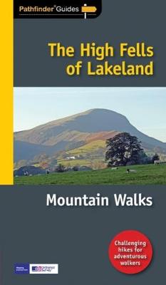
Do you enjoy a hill-walking challenge with impressive mountain-top views?

Inside Pathfinder (R) Guide to the High Fells of Lakeland are 20 majestic and challenging fell walks amid the glorious scenery of the Lake District mountains with clear and easy-to-follow route directions compiled from the author's 40 years' experience of Lakeland walking.

For adventurous ramblers and walkers wanting a hill-walking challenge, this brand new Pathfinder (R) walking guide features 20 demanding day-walks in the mountains of the Lake District, from Scafell Pike (highest mountain in the Lake District), to Helvellyn, Skiddaw, Great End and Bowfell - all over 900m (nearly 3000 feet) high.

Giving a detailed guide to 20 inspiring expeditions on the high fells of Lakeland, Pathfinder (R) Guide to the High Fells of Lakeland explores some of the best fell walking country in the Lake District. With views over to Buttermere, Derwentwater and Grasmere, the Lakeland Fells offer some of the most superb experiences of the Lake District for the adventurous walker and Pathfinder (R) Guide to the High Fells of Lakeland allows ramblers to easily enjoy these mountain views with clear, large-scale Ordnance Survey route maps and GPS waypoints to help you navigate your walk with ease.

If you're a walker who really wants to make the most of what Wainwright described as the `splendid walking country' of the Lake District, make sure you don't set off on your fell walk without a copy of Pathfinder (R) Guide to the High Fells of Lakeland in your rucksack.

Pathfinder (R) Guides are Britain's best loved walking guides. Made with durable covers, they are the perfect companion for countryside walks throughout Britain. Each title features circular walks with easy-to-follow route descriptions, tried and tested by seasoned walkers and accompanied by beautiful photography and clear, large-scale Ordnance Survey mapping.

PF03

The Isle of Skye

by Terry Marsh

Published 31 August 1996

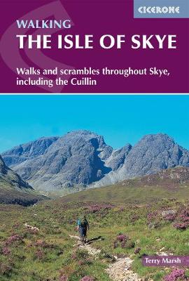
This guidebook describes 87 of the best walks and scrambles on the Isle of Skye. Not only limited to the popular routes on the Black Cuillin or Skye's 12 Munros, the guide offers a comprehensive selection of routes in all areas of the island; in Sleat and South-East Skye, Strath, Minginish, Duirinish, Waternish and Trotternish. The routes range in length from 2 to 23km, so while there are opportunities for novice walkers, routes can also be combined for longer trails and difficult scrambles.

Skye can delight walkers and scramblers at every turn, from sea stacks to fell tops; corries to rugged cliffs and plenty in between. Walkers on Skye should be prepared for strenuous trails and wilderness, as well as changeable weather, navigation, and - depending on the route - scrambling skills.

Alongside detailed descriptions and OS maps for every route, the guidebook also includes practical information essential to making the most out of a visit to Skye. From travel to and around the island, to advice on accommodation, where to stock up on supplies and who to call in emergencies. The result is an excellent companion to exploring the best of Skye.


PF60

Lake District

by Terry Marsh

Published 31 March 2000
Pathfinder(R) Lake District covering Coniston, Kewswick and Devoke Water. This selection offers interest, regional variety and balance of routes in the Lake District providing the best walks in the area. From an easy stroll through Buttermere to the much more challenging walks in Rosthwaite and Stonethwaite this volume contains something for everyone. Covering walks through the whole of the Lake District both popular and little know scenic routes including Bowfell, Wetherlan and the Langdale Valleys. -See walk locations by Looking Inside Inside: -28 great walks in the Lake District from 2 to 10 miles -Clear, large scale Ordnance Survey route maps -GPS reference for all Lake District waypoints -Where to park, good pubs and places of interest en route -All routes have been fully researched and written by expert outdoor writers -Beautiful photography of scenes from the walks Pathfinder(R) Guides are Britain's best loved walking guides. Made with durable covers, they are the perfect companion for countryside walks throughout Britain. Each title features circular walks with easy-to-follow route descriptions, large-scale Ordnance Survey route maps and GPS waypoints.With over 70 titles in the series, they offer essential information for walkers throughout the country.

PF10

Snowdonia

by Terry Marsh

Published 6 June 2016
Short Walks Snowdonia covering parts of Abergynolwyn, Conwy and Snowdon. This selection offers interest and regional variety in Snowdonia, providing the best short walks in the area. Covering walks through the whole of the Snowdonia, both popular and little know scenic routes including the Eastern Moors and the River Lathkill. - See walk locations by Looking Inside Inside: -20 circular walks up to 5 miles - Clear, large scale Ordnance Survey route maps - GPS reference for all Snowdonia waypoints - Where to park, good pubs and places of interest en route - All routes have been fully researched and written by expert outdoor writers - Beautiful photography of scenes from the walks Ideal for families, or for those who prefer shorter distances, Short Walks guides contain 20 walks graded by distance, duration and difficulty. Each route includes points of interest as well as fun observation questions for children.

PF15

Yorkshire Dales

by Terry Marsh

Published 5 April 1999
Pathfinder Yorkshire Dales covering parts of the National Park, Ribblesdale and Swaledale. This selection offers interest, regional variety and balance of routes in the Yorkshire Dales providing the best walks in the area. From an easy stroll through Ingleton Waterfalls to the much more challenging walks in Gunnerside, this volume contains something for everyone. Covering walks through the whole of the Yorkshire Dales both popular and little know scenic routes including Wharfedale, Wendleydale, and Burnsall. -See walk locations by Looking Inside Inside: 28 great Yorkshire Dales walks from 2 to 10 miles -Clear, large scale Ordnance Survey route maps -GPS reference for all Yorkshire Dales waypoints -Where to park, good pubs and places of interest en route -All routes have been fully researched and written by expert outdoor writers -Beautiful photography of scenes from the walks Pathfinder Guides are Britain's best loved walking guides. Made with durable covers, they are the perfect companion for countryside walks throughout Britain. Each title features circular walks with easy-to-follow route descriptions, large-scale Ordnance Survey route maps and GPS waypoints.With over 70 titles in the series, they offer essential information for walkers throughout the country.