Getmapping S.
3 total works
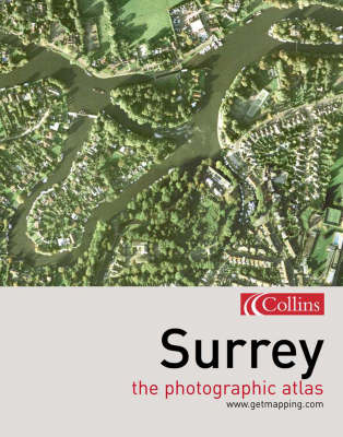
This revealing atlas covers the whole of the county of Surrey. It combines the vertical aerial photography of Getmapping.com with Collins' street and road mapping - a combination of photography and cartography. If you live, work in, or simply visit or love the county of Surrey you will already possess a personal stake in this book - within its pages you will be able to find your house, perhaps locate your car parked in the street, trace your route to work, and visit some of your favourite places. With close-up views of major towns such as Kingston-upon-Thames, Richmond, Reigate, Epsom, Leatherhead, Redhill, Staines, Weybridge, Woking, Camberley, Guildford, Haslemere, and Farnham it is a unique record of the whole county. On closer inspection you will spot patterns that are invisible from the ground, discover surprising links between unconnected areas, find large areas of greenery that you never knew existed, and explore new neighbourhoods for the first time.
The photography and the cartography share the same standard grid system, meaning you can cross-reference quickly between the two elements; both photography and cartography are "map accurate", as the photography has been geo-corrected, a process that removes the distortions in the original aerial photography; and throughout the whole book the grid interval is 500 metres, so that distances can be accurately assessed.
The photography and the cartography share the same standard grid system, meaning you can cross-reference quickly between the two elements; both photography and cartography are "map accurate", as the photography has been geo-corrected, a process that removes the distortions in the original aerial photography; and throughout the whole book the grid interval is 500 metres, so that distances can be accurately assessed.
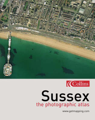
This revealing atlas covers the whole of the county of Sussex. It combines the vertical aerial photography of Getmapping.com with Collins' street and road mapping - a combination of photography and cartography. If you live, work in, or simply visit or love the county of Sussex you will already possess a personal stake in this book - within its pages you will be able to find your house, perhaps locate your car parked in the street, trace your route to work, and visit some of your favourite places. On closer inspection you will spot patterns that are invisible from the ground, discover surprising links between unconnected areas, find large areas of greenery that you never knew existed, and explore new neighbourhoods for the first time. The photography and the cartography share the same standard grid system, meaning you can cross-reference quickly between the two elements; both photography and cartography are "map accurate", as the photography has been geo-corrected, a process that removes the distortions in the original aerial photography; and throughout the whole book the grid interval is 500 metres, so that distances can be accurately assessed.
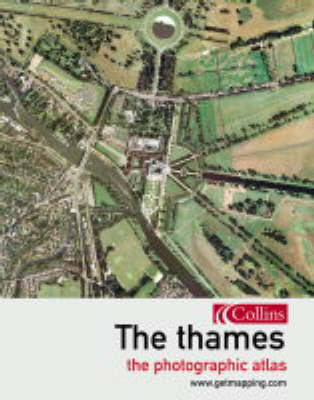
The Thames is an enthralling visual walk from along England's greatest river, from its source to the sea, which combines Getmapping's spectacular aerial photography with fascinating facts on the history, life and times of the places along the riverbank. The Thames and the communities which lie along its banks contain an astonishing wealth of sites of historical and cultural importance and of natural beauty. Getmapping The Thames allows you for the very first time to see this astonishingly rich and diverse landscape from the air. Starting at the source of the Thames in Oxfordshire and proceeding along the river right to the estuary and the sea, the book combines Getmapping's high-quality aerial photography with facts and pocket histories of all the places you will encounter along the way. The pace varies too, from leisurely looks at areas of outstanding natural beauty to indepth spreads on historical 'must-sees' such as Hampton Court or Greenwich. From information about locks and cruising along the Thames to the dark and brooding history of the Tower of London. 240 pages of aerial photography, from the Thames to the sea.