LANCASTER IMPRINTS
10 primary works
Book 15
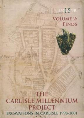
The results of the work will greatly enhance understanding of the development of the fort during the Roman period, and of Carlisle's role in the origins and development of the Tyne-Solway frontier system. Important evidence for occupation within the medieval castle's outer ward was also recovered, and the large ditch separating the castle from the city was investigated. Waterlogging of the lower levels resulted in exceptional preservation of organic materials, which rarely survive on archaeological sites in Britain. These included the remains of numerous wooden buildings and other structures within two superimposed timber forts of the late first- to mid-second century AD, a multiplicity of wooden and leather artefacts of Roman and medieval date, and a wealth of environmental information.
Volume 2 presents detailed evidence of the artefacts and ecofacts from the site. It draws together the many reports produced by specialist researchers into a synthesis and discussion. This sheds light on day-to-day activity in and about both the Roman forts and medieval outer ward of the castle and illustrates the lives of those who built and inhabited the buildings within them. Much of the detailed project data have been compiled into a third, digital, volume; this takes the form of a DVD accompanying this book.
Book 16
In 1966, the site was presented to Runcorn Development Corporation by Sir Richard Brooke. Ground-breaking excavations began in 1970, running until 1987, and exposing much of the site for investigation. The principal excavator, J Patrick Greene, published an excellent synthesis of the site in 1989, but the full stratigraphy and finds from the project remained unpublished.
This book, funded by English Heritage, and supported by the Norton Priory Museum Trust, seeks to redress this, with a full account of the results of the excavations. Its production by Oxford Archaeology North drew together a team of specialists from a wide range of disciplines.
Book 17
Bewsey Old Hall, Warrington, Cheshire
by Jennifer Lewis, Richard Heawood, and Christine Howard-Davis
Having been owned by the Butlers until 1586, ownership passed briefly to the Earl of Leicester, but it was soon sold on to the Ireland family, later passing to their successors, the Athertons. In the late sixteenth or early seventeenth century, a fashionable new brick house was built on the site, incorporating or reusing elements of the medieval hall. It was much enhanced in the seventeenth century by the creation of a formal terraced garden furniture, although the terracing had been levelled by 1724.
Bewsey's remaining medieval structures were demolished during the eighteenth century, when the hall was extended, and landscaping works filled in parts of the moat and enlarged others as water features. In 1863, a 'New Hall' was built, and Bewsey Old Hall was left in the hands of tenants, until, in considerable disrepair, it was acquired by Warrington Development Corporation in 1974.
During the late 1970s and until the mid-1980s, the site's development was traced through examination of the building, extensive excavation, and documentary research. This volume paints a vivid picture of Bewsey's development, the trials and tribulations of its inhabitants, and their relationship with the world around them.
Book 18
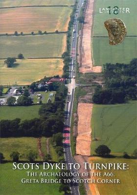
One of the most significant results was the important new dating evidence for a section of the Scots Dyke, a substantial linear earthwork between the Rivers Tees and Swale. It has been dated to the early-middle Iron Age, which places it within the wider Iron Age and Roman landscape revealed by the road improvement scheme. This may indicate that it was related in some way to the Iron Age tribal centre at nearby Stanwick.
The volume arises from a multi-disciplinary approach to the archaeology, with the emphasis placed on interpreting the sites within their wider landscape context. It involved a multiplicity of authors, ranging from staff at Oxford Archaeology North, to external specialists, including staff at Lancaster University and University College, London.
Book 22
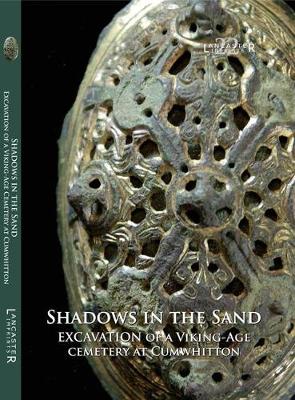
Shadows in the Sand
by Caroline Paterson, Adam J. Parsons, Rachel M. Newman, Nick Johnson, and Christine Howard-Davis
Six burials were found, dating to the early tenth century, but almost no skeletal material survived. The burials were richly furnished, with a wide range of artefacts, including swords, spearheads, spurs, knives, and numerous other objects. These were poorly preserved, but the careful excavation, conservation, and analysis has produced a wealth of information about their original appearance, manufacture, and use. A rare decorated drinking horn, seax with a silver-inlaid horn handle, a locking wooden box, and a unique group of copper alloy buckles and strap ends were especially notable.
This rare opportunity has allowed the study of a closely linked group of Viking burials, probably of a single family and seemingly of not more than two generations. It has highlighted both the similarities and differences between the graves, which might point to some individuality in the burial rites, and the diversity of the cultural origins of the objects that furnished them. Most importantly, this site has provided a tantalising glimpse of the cultural origins, beliefs, and status of these people and how they may have fitted in the volatile political landscape of tenth-century Cumbria.
Book 23
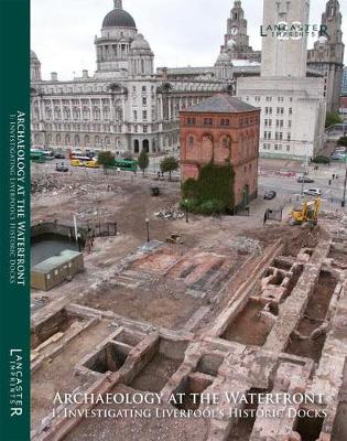
Archaeology at the Waterfront vol 1
by Richard A Gregory, Caroline Raynor, Mark H. Adams, Robert Philpott, Christine Howard-Davis, Nick Johnson, Vix Hughes, and David A Higgins
The archaeological evidence has been complemented by detailed historical research, which together provide significant insights into the dynamic and evolving system of dock and quayside development, occurring between the early eighteenth and early twentieth centuries. This development was integral to Liverpool’s wider history, and the archaeological remains reflect the port’s nascent post-medieval growth, commercial zenith during the nineteenth century, and eventual twentieth-century decline, prior to the extensive schemes of urban regeneration which now characterise the present-day waterfront. Moreover, this extensive campaign of investigation indicates how archaeology along the waterfront represents an important technique for uncovering the nuances of an area that was integral to the rise and success of Liverpool, and which also continues to exert a significant sway on Liverpool’s cultural and economic identity.
Book 24

From Mesolithic Encampment to Medieval Estate
by Jeremy Bradley and Christine Howard-Davis
The archaeological investigation was focused on seven areas that had been defined by almost a decade of preliminary works. The earliest remains included evidence of prehistoric settlement, at a location that had seen repeated activity in the Mesolithic and Neolithic periods, and during the Bronze Age. The findings make a significant contribution to the understanding of several millennia of human activity that are otherwise poorly understood in Lancashire.
The most extensive remains, dating from the twelfth to the mid-fifteenth century AD, were found on either side of the Howgill Brook. Several buildings, in both timber and stone, as well as kilns and channels, are thought to represent the remains of one or more water mills associated with Beaumont Grange, an estate belonging to Furness Abbey.
This volume arises from the multi-disciplinary approach to the archaeological sites, with the emphasis placed on the integration of a wide range of data. It comprises the work of several authors from Oxford Archaeology, as well as external specialists.
Book 25
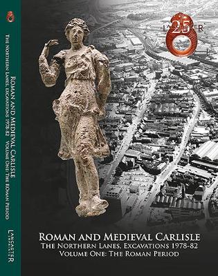
Roman and Medieval Carlisle: the Northen Lanes, Excavations 1978-82
by John M. Zant and Christine Howard-Davis
For post-excavation purposes, the project was split into two parts, the northern and southern Lanes, the results of the latter being published in 2000. The current volume presents the evidence for Roman occupation within the northern Lanes, from the construction of a probable military camp and a series of large timber buildings, possibly mansiones, in the early Roman period, to the expansion of civilian settlement across this area during the mid-late second century AD, which saw the emergence of a distinct pattern of building plots. Good preservation of waterlogged organic materials was a feature of the earlier levels, which yielded a wealth of environmental information and many artefacts of wood and leather. The post-Roman evidence from the northern Lanes will be presented in a companion volume.
Book 26
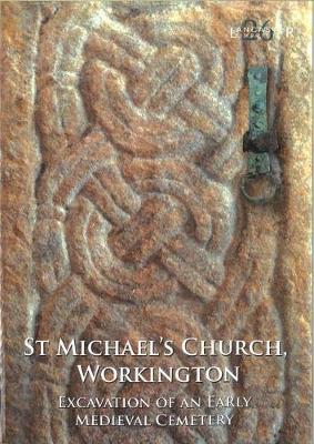
The project has provided a rare opportunity to study the origins of one of the earliest, and long-lived, early medieval Christian cemeteries in North-west England. The work focused upon the evidence for pre-Norman ecclesiastical activity and the earliest phases of the medieval parish church, together with the skeletal remains, and artefacts. It also provided an opportunity to conduct a series of scientific investigations on the material, since bone rarely survives in Cumbria, This included radiocarbon dating, isotope analysis, and osteological analysis, providing the earliest radiocarbon dates from such a cemetery in Cumbria, indeed in the North, and two clear phases of burial, the second, closely dated to the eleventh century, containing evidence of a particularly gruesome end for one of the interred. The large collection of mid-tenth- to early eleventh-century sculpture, decorated with Scandinavian-derived motifs and interlace, and items of personal dress and jewellery, indicated the evolving tastes of the patrons.
This has allowed a better understanding of the lives of this community, and their changing burial traditions. Perhaps most importantly, the site provided an opportunity to marry the patchy historical framework of the region with archaeological evidence, providing information for how people responded to the changing tastes, politics, and events within the landscape of the North West in the early medieval period.
Book 27
The earliest feature was a small ditch, possibly part of a late pre-Roman or early Roman field system, but there was little evidence for activity before the late Hadrianic period (c AD 130+), when a timber ‘strip building’ was constructed on the street frontage. This went out of use in the mid-second century, but was immediately replaced by a similar structure. Following the demolition of this building around the end of the century, the plot was seemingly abandoned for a time, after which a stone-footed strip building was erected, probably c AD 220-30. Although direct evidence was sparse, all three buildings may have been multifunctional, possibly combining residential and commercial functions. To the rear was a palimpsest of features, including plot-boundary ditches and a group of wells and/or water cisterns.
The Roman properties on either side of this also contained stone-footed strip buildings during the third century, one separated by a minor road, extending north-west from the main road. The stone-footed building, and probably also those in the adjacent plots, had been demolished by c AD 270. Subsequent activity was extremely limited, but included the cutting, in the late third/early fourth century, of a ditch along the north-eastern boundary of the targeted plot. Thereafter, the site seems to have been abandoned completely, and no evidence of post-Roman activity was identified