Great Treks of the Alps
1 primary work • 3 total works
Book 1
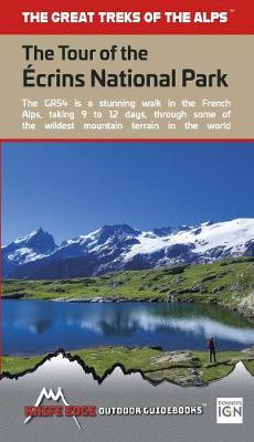
The complete guidebook for the Tour of the Ecrins National Park (GR54) in the French Alps. The only guidebook with Real 1:25,000 Maps: proper mapping included for each stage. This makes navigation easy and saves you money: no need to buy additional maps. Also includes: -Unique Itinerary Planner: plan a bespoke itinerary to match your ability and vacation schedule. All difficult calculations of time, distance and altitude gain are done for you -4 Proposed Itineraries of between 9 and 12 days -Everything the trekker needs to know to plan the route: route descriptions, costs, budget, difficulty, weather, how to get there, and more -Full accommodation listings: spectacularly situated mountain huts, villages, hamlets and campsites -Information for both self-guided and guided trekkers -Edge to edge colour: the most beautiful trekking guidebooks in the world The Tour of the Ecrins National Park (GR54) is arguably the finest trek in the Alps. It is an epic journey around the unforgettable Ecrins which has the highest mountains in the French Alps outside of the Mont Blanc Massif. This is one of France's 'crown jewels' and yet is hardly known to the English speaking world. -193km -9-12 days -12,000m of altitude gain -14 mountain passes Unspoilt and remote high mountain terrain: snow frosted summits, beautiful valleys and pastures, sparkling azure lakes, carpets of wild flowers, the soothing sound of cow bells and easy to follow paths. This trek should be on your hiking bucket list.
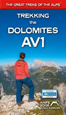
This is only guidebook exclusively for the AV1 and contains everything needed plan and walk Italy's most popular long-distance route. The guidebook contains real maps - Tabacco 1:25,000 - the finest maps available for the Dolomites, thus making navigation easy with no need to carry additional maps.
The AV1 is the premier route in the Dolomites. It is the perfect way to explore the range's exquisite beauty and fascinating WW1 history. The AV1 is a linear route between Lago di Braies in the north and Belluno in the south. On the journey, you cross incredible high mountain passes, travel through magnificent valleys, exquisite alpine plateaus, wonderful grassy pastures and carpets of wildflowers.
Unlike some alpine treks, the AV1 never enters villages or hamlets: fabulous accommodation is available in remote mountain huts cleverly spaced out along the route. Places with views that most people dream of but few will ever see. This is without a doubt a trek that should be on your bucket list.
With the right preparation, planning and approach the AV1 is perfectly manageable for most people of reasonable fitness. It is challenging but achievable. Most of what you need to know to prepare for the AV1 is here within these pages. And the entire route is described in detail to guide you on the trek itself. Furthermore, unlike other books, this one contains Real Maps: for each stage, there is a 1:25,000 scale map.
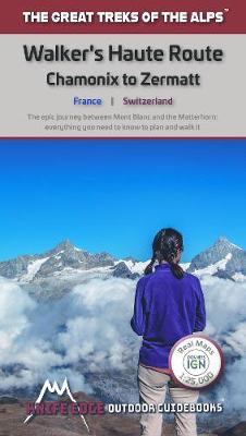
An incredible trek between the two most famous mountain towns in the Alps. Travelling from Chamonix in France to Zermatt in Switzerland, you will start at Mont Blanc and finish at the Matterhorn. On the way, pass the largest collection of snowy 4000m summits in the Alps: Mont Blanc, Grand Combin, the Weisshorn, the Zinalrothorn, the Dom, the Taschhorn, the Breithorn and the Matterhorn, to name a few.
206km; 10-14 days; 14,000m of altitude gain; 12 mountain passes; 2 countries, France and Switzerland.
Unspoilt and remote high mountain terrain: amazing glaciers, snow frosted summits, beautiful valleys and pastures, sparkling azure lakes, carpets of wild flowers and the soothing sound of cow bells. This trek should be on your hiking bucket list.
-Real maps for each stage: 1:25,000. No need to buy a separate map!
- Unique Itinerary Planner: plan a bespoke itinerary to match your ability and vacation schedule. All difficult calculations of time, distance and altitude gain are done for you.
- Everything the trekker needs to know: route descriptions, costs, budget, difficulty, weather, how to get there, and more
- Full accommodation listings: spectacularly situated mountain huts, villages and hamlets
- Full section on camping: a complete list of camping locations
- 13 exciting variants to the main route!
- Information for both self-guided and guided trekkers