Considered to be the capital of Upper Swaledale, the village of Reeth stands high above the confluence of the River Swale and the Arkle Beck and over the centuries has kept watch over the changing face of the dale. Here the Mesolithic hunter/gatherer came on his foraging expeditions, the Bronze Age tribesmen created cattle ranches and began the early steps into agriculture and clashes arose between the native Celts and the invading Anglians who were to form the embryonic England. The Vikings who recognised the similarities between their home and this little rugged dale came and settled, creating as they did so a character that can still be recognised today. During the Medieval period large religious houses became established, evidence of which still exists on the ground and in place names. Then in the 17th and 18th centuries the industrialisation of the dale took place with hundreds employed in the mining and associated industries. Join the writer in a series of walks that explores both the countryside and the history that shaped it, in this corner of what is thought of as the most beautiful of all the Yorkshire Dales.

The Simonside Hills were a special place for our ancestors and for many people still are. Part of a range of sandstone hills that run up the centre of Northumberland between the Cheviots and the sea, these hills present a wide variety of countryside for the walker to explore. Running between Coquetdale and Redesdale, to the east the Hills end in the Simonside Ridge, a famous landmark of crags and rocks. To the west, the landscape gradually changes from moorland to rough farm pasture while in the centre the wooded bulk of Harwood Forest dominates. Here, in this varied landscape, mankind has left many reminders of his presence through the ages. From the Stone Age to the 1940's, there are the remains of habitation and of conflict. Join the author as in a series of nine walks he discovers this special countryside.

Walking in Weardale

by Keven Shevels

Published 2 July 2012
Taking it's name from the river which starts with the joining of several small streams at Wearhead, the dale stretches from the high moors above Killhope to the flatter, lower lands just east of Wolsingham. The scenery changes as the river travels down the dale, from the bleak, heather clad moors and rocky outcrops to gently undulating stone walled fields. The river itself changing too, from a small rocky rushing flow of water it gradually absorbs tributaries on it's descent through the dale to become wider and slower as it becomes, ultimately, one of the great rivers of the North of England. Weardale is basically a farming area, although for centuries the wealth of it's minerals and underlying stone have created industries that in the past have created both riches and poverty for it's inhabitants. One of the lead dales of the North Pennines, which made Britain the centre of the world's lead industry during the 18th and 19th centuries, lead was only one of the underground treasures which kept the extraction industries going well into the 20th century when they finally met their demise.
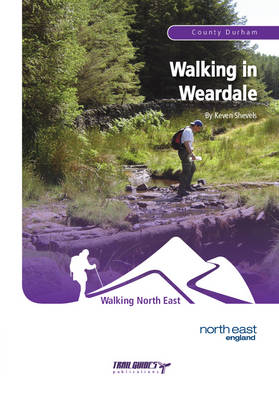
Today the population of the dale is much smaller than it was two hundred years ago and, aside from agriculture which is still a vital part of the dale's economy, much of the dale is benefiting from an increasing growth in tourism. In particular, the walker can experience here a full and varied landscape from the fields and meadows of the lower dale, the purple clad heather grouse moors in summer and, at the top end of the dale, one of the wildest and bleakest unspoilt natural landscapes in Britain. Weardale is very much an under appreciated and relatively undiscovered part of Britain and for the walker, who can really understand what this valley can offer, then long may it be so. The nine walks in this book have all been designed to explore the woods, hills and moors while showcasing the landscape and history of this dale.

Walks Around Gunnerside

by Keven Shevels

Published 15 May 2011
The small village of Gunnerside lies in the heart of Swaledale, which is regarded by many as the most stunning of all the Yorkshire Dales. Originally settled by the Vikings in the dark years following the end of the Roman occupation, Gunnerside has seen many changes over the millennia but nowadays it is perhaps best known for being one of the traditional, stone built little villages that inhabit these rugged dales. However,step away from the well-worn tourist trail to discover the country surrounding it and you will find a rich and varied heritage lying hidden amongst the fields and moors of this landscape. In this series of eight walks starting from the village, the author explores the countryside surrounding it and the legacy that a hard and stern history has left behind.

Walking in Teesdale

by Keven Shevels

Published 1 March 2014
The River Tees is one of the major rivers of the north and in it's upper reaches is a heaven for walkers. Here the river descends from the high Pennines, flowing between high moorland peaks as it makes it's way down the valley. Then as the hills gradually lose their height and become less stern, the wildness that characterises the upper dales gives way to pastureland, woodland and pleasing riverbank walks. However, don't just think of Teesdale as the main river valley. The major tributaries of the Tees all flow in from the west, these being the rivers Balder, Lune and Greta, while on the eastern side an ample number of smaller becks and streams flow in giving a number of hidden side-valleys that can be a joy to explore. Together with the main river valley, this presents a vast area to walk in for those willing to step away from the popular Pennine and Teesdale Ways. While there are elements of both these national trails included in the routes of a couple of these walks, in the main this guide book takes you away from the more frequented areas and presents a mixture of countryside.
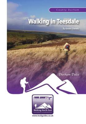
Here you can venture onto the wild open moors, explore wooded side-valleys and stroll along the riverbanks of the rugged but beautiful River Tees itself. But the countryside of Teesdale is not just about the scenery, splendid though that is. Like many upland areas of the north, lack of cultivation and ploughing has meant that the hills have retained much of the history that has been lost on lower-lying ground. If you know where to look, then a walk through Teesdale can be a fascinating education. In many ways Teesdale is one of the original 'open-air museums'.

Walking in Arkengarthdale

by Keven Shevels

Published 31 December 2016

The village of Osmotherley lies on the edge of the North York Moors National Park, at the point where the rugged Cleveland Hills meet the more gentle, rolling Hambleton Hills. This is an area with a history that stretches back to the early days of human exploration and settlement. A history that has left it's mark right up to the present time. Here the walker is presented with a mixture of landscapes to explore. The rugged, heather moorland, the rolling grassland of the lower hills, and the forests of conifer and broad-leaved trees that line the edges of the moors. Join the author on a series of walks as he explores both the landscape and the history of this part of one of the country's most popular national parks.

The small market town of Helmsley lies on the southern edge of the North York Moors National Park and flowing past the edge of town lies the River Rye. Born high on the slopes of the Cleveland Hills, this river cuts a deep sided valley as it makes it's way through the flat-topped Tabular Hills passing Hawnby, Rievaulx and finally Helmsley before entering the Vale of Pickering. As it heads north-west from Helmsley, a network of footpaths takes you through this valley, along wooded trails and riverside fields to the heather clad moors that line the upper reaches of this quiet, little dale. For the walker, this presents some of the best countryside that Yorkshire has to offer. It's little wonder that the medieval monks chose this valley to site their monasteries and settlements. Here history mixes with the countryside with four thousand years of human habitation lying amongst the trees, in the fields and across the moors. A walk here tells you much more than where your next footstep goes.

Walking in the Allendales

by Keven Shevels

Published 31 January 2015
Rising in the North Pennines, on the Durham/Northumberland border, two rivers, the East and West Allen, flow northwards to join and then, ultimately, enter the River South Tyne. Here, within sight of the high Pennines, these rivers have created two rugged little valleys that for centuries were part of the 'lead dales', the North Pennines Orefield that dominated the world's lead industry. Here the landscape has a different look and feel to it than the other more popular walking areas of Northumberland such as the Cheviot Hills or Hadrian's Wall. Travelling from the high moors to the wooded valleys, join the author as, in a series of nine walks, he explores both the landscape and the heritage of these two dales and discovers what makes them so special.

The Hambleton Hills lie in the south-west corner of the North York Moors National Park. This is an area that is justifiably known for its varied landscape, a land of flat-topped hills interspersed with wooded and tranquil valleys. To the north, the hills are heather-clad moor inhabited by sheep and grouse, then as they gradually run south-wards, their nature changes to more gently rolling hills clad in woodland and fields of grain. This is a fascinating area, one that has seen mankind take his early steps into agriculture, the introduction of Christianity to this land, and the successful and unsuccessful foreign invader. History has left a pattern on this landscape, one that can be traced as you walk. Join the author in a series of nine walks as he explores both the countryside and history of one of the country's most popular national parks.

Walking in the Cleveland Hills

by Keven Shevels

Published 31 December 2020
Part of the North York Moors National Park, the Cleveland Hills run along the north-west edge overlooking both Cleveland and Teesside. The name Cleveland coming from the Old English meaning 'land of the cliffs' which reflect its rugged escarpments. Here you have the highest points in the National Park, wild windswept heather moorland and wooded escarpments and valleys.

This is a land that saw the footprint of early man and yet was also a catalyst of the Victorian industrial revolution. In a series of nine walks, join the author as he explores this varied area and discovers part of its secret past.